Monitoring dams from space
Catastrophic dam failures can lead to death, destruction and long term pollution, but monitoring the world’s dams is often difficult and expensive. Here, Craig Goff explains how HR Wallingford’s remote monitoring system – DAMSAT – uses space technology to offer an alternative to on-site inspections, so communities at risk from failing dams can be protected from disaster.
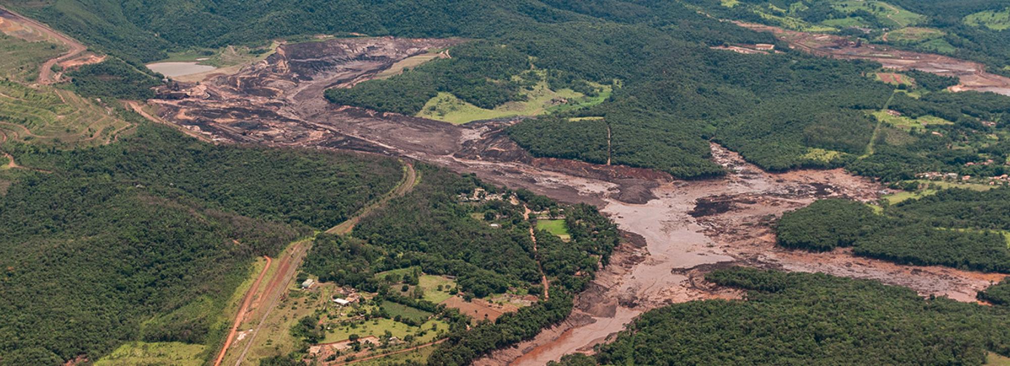
It took just 15 seconds one lunchtime in January 2019 for the Córrego do Feijão dam near Brumadinho in Brazil to morph from looking normal into not being there. The dam, built in 1976, held back the waste products of an iron ore mine. It was, according to its owners Vale, subject to regular monitoring. But that day something went terribly wrong: 12 million cubic metres of waste cascaded down the valley, destroying everything in its path. At least 270 people perished. Some areas were buried under 15 metres of sludge.
In February 2021 it was announced that communities affected by the Brumadinho catastrophe would be given a $7bn pay-out from the owners, but the clean-up will take years to complete. While the breach was one of Brazil’s worst industrial disasters, it wasn’t a one-off. Just over three years earlier, in November 2015, a tailings dam operated by a Vale subsidiary collapsed, killing 19 and destroying two villages.
An ancient science; an uncertain present
Humans have been building dams for thousands of years. Nobody knows exactly how many exist today; the estimates are mind boggling, and vary wildly. The real number could exceed the number of officially documented structures several times over and could amount to many hundreds of thousands of dams worldwide. ICOLD, the International Commission for Large Dams, holds information on bigger structures (although it’s important to note that not everyone defines ‘large dam’ the same way). According to them, there are around 58,000 structures with walls higher than 15m, holding a combined 16,201 km3 water. That’s the equivalent of 6.5 billion Olympic sized swimming pools.
No database of smaller structures exists, but they are certain to run into the many hundreds of thousands. There are other issues with the ICOLD numbers: their data is only gathered from 100 countries; there may well be double or triple the number of large dams in addition to those listed on their system, plus there are the smaller dams which fall outside of their definition. The number of tailings dams, which hold back mining waste rather than water, are even more difficult to pin down. One often cited paper suggests there may be 3,000 but that paper ignores China and some other big territories where we know there are a lot of tailings dams. Another paper talks about 30,000. So the picture is at best uncertain. What is not up for debate is that dams need to be monitored, regularly and properly.
A toxic mix
Tailings dams often hold back a toxic mix of chemicals, rock and rubble, which you wouldn’t want polluting the water course. For a variety of reasons including poorer standards of both build quality and regulation, these dams are much more likely to fail than structures holding back water. Internationally, the statistics show that out of every 100 tailings dams, one will fail every year.
Unlike a water dam, which is seen as an asset, tailings dams are often regarded (especially by small, less reputable companies) as ‘out of sight, out of mind.’ Once they are finished with, the mine owners will often move on, leaving the structures completely unmaintained - and unmonitored. And even those dams being monitored can fail if that monitoring is inadequate, which is frequently the case because of a lack of resources. The traditional on-the-ground methods involve techniques like measuring drain flows over weirs, dipping tape measures into standpipe piezometers, conducting surveys into settlement levels, and even drone surveying, but the monitoring is only as good as the resources available.
Space based and multi-disciplinary
It was this problem, combined with a funding opportunity from the UK Space Agency’s International Partnership Programme (IPP) that resulted in a conversation here at HR Wallingford between my dams, breach, flood and machine learning colleagues about how we could use satellite technology to stop tailings dam disasters happening. The results of this thought experiment was our tool – DAm Monitoring from SATellites (DAMSAT). The project was developed by an HR Wallingford-led consortium, and launched as a pilot in Peru in 2018 – months before the Brumadinho disaster. Funding was then extended to include water dams in the country’s Pasco region.
The space sector has opened up new areas of opportunity to address environmental and social challenges using Earth Observation (EO) technology. Data alone, though, isn’t enough. You need to really understand the data and what it means, before you can turn it into useful knowledge. Our aim was to bring together some quite well understood technologies in one place, from an engineering, rather than a data-seller point of view. To this end, we brought together not only EO specialists, but civil engineers, owners, regulators and IT experts.
Our own expertise in EO, dam safety, and flood risk modelling has enabled us to develop a system that provides continuous, remote monitoring of dams, with automatic alerts generated if anything untoward happens. DAMSAT offers a practical solution which can be seamlessly integrated with existing on-site systems, typically movement sensors, and piezometers which measure pressure of fluids. Working with so many different disciplines has been challenging, but as a result we believe we’ve built a better system.
Past, present, future
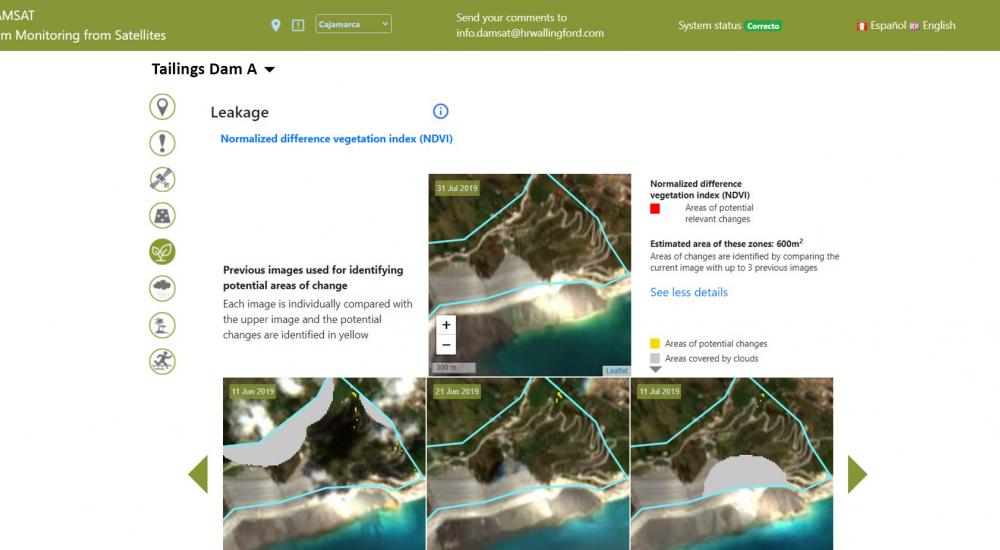
By analysing a wide range of information types from today, and comparing what’s happening on the ground with historic data, DAMSAT is able to provide a powerful risk assessment tool to prevent future catastrophe. A dam’s health can be assessed by comparing its current condition with past images to spot any changes that could signify the presence of potential leaks or movement. The health of downstream vegetation is monitored – sick plants could be the result, for example, of chemicals leaching from the tailings. To do this, DAMSAT uses a variety of satellite EO data products, including data from Interferometric Synthetic Aperture Radar (InSAR) and Global Navigation Satellite System (GNSS) technologies, combined with accurate 5-day and 10-day forecasting from the National Oceanic and Atmospheric Administration or the European Centre for Medium Range Weather Forecasting. Using the weather forecasting data, DAMSAT can calculate what is likely to happen to river flows, and how this in turn is likely to affect the level of a reservoir. The information is then turned into automatic alerts and warnings which appear on a desktop interface.
The ability to give warning days or even hours in advance is hugely powerful. (In the UK, risk guidance includes scenarios based on ‘no warning’ and ‘with warning’. The ‘with warning’ scenario is based on 1.5 hours.) When we modelled the Brumadinho disaster it showed that with just 15 minutes’ warning the death toll could have been reduced from 270 to zero.
Monitoring water supply reservoirs
Having been extensively piloted in Peru, DAMSAT is now up and running in the UK, which on average experiences a serious near-miss about once per decade, most recently at the Toddbrook reservoir in Derbyshire. In August 2019, after two major storms, 1,500 people had to be evacuated from the town of Whaley Bridge when the auxiliary spillway failed. Disaster was only averted thanks to a mammoth effort to reinforce the damaged reservoir. Professor David Balmforth’s report into Toddbrook noted that the reservoir owners had been compliant, but, critically, that ‘compliance with the law in itself did not necessarily equate to safety.’ Balmforth’s later report into the future of the UK reservoir industry went on to highlight DAMSAT as a technology that could help improve dam safety monitoring. For example Bristol Water is now adopting the system to monitor its 15 large raised reservoirs from space and, we hope, they are the first of many organisations that will embrace the system. As climate change continues to impact our weather patterns, pressure on ageing infrastructure can only increase. At the same time we’re going to see growth in dam construction for irrigation, human consumption of water, hydropower and mining. Against this backdrop the potential role for DAMSAT to protect both humans and the wider environment in the vicinity of these essential, but potentially fatal, structures is huge.
The future for DAMSAT
DAMSAT is designed to bridge the gap between technology and practical, operational applications, turning EO data into context-specific, meaningful information that can be acted upon locally. Ultimately, we hope DAMSAT will help ensure the safety of communities whose day to day is blighted by the fear of another Brumhadinho style disaster: consider, in the state of Minas Gerais alone, where Brumadinho lies, there are 200 dams classified as high risk.
Both life and business is about risk management. DAMSAT is an immensely powerful risk management tool, whether you own the structure, regulate it, or insure it. Even small, incremental improvements in dam safety can have massive benefits in avoiding loss of life, reputation, and money. We made a presentation about DAMSAT to a large mining corporation. Their response was striking: we can’t unsee this now. We have to do something.
Those communities living downstream of the tens of thousands of tailings and water dams across the globe can only hope the world catches on.

Image (top) credit: Ibamagov under the terms of cc-by-sa-2.0.
Want to know more?
