
Secondary nav 2022

  • Equipment
  • Software
  • Training

Main navigation 2022

  • About
    • About HR Wallingford
    • Our leadership
    • Our people
    • Our impact
      • Annual report & financial statements
      • Gender pay
      • Social impact
      • Sustainability
    • Our story
    • News
    • Insight articles
    • Policies
  • Projects
  • Expertise
    • Coastal & marine sustainability
      • Coastal hazards & resilience
      • Coastal morphology & sediment dynamics
      • Dredging and sediment management
      • Marine & coastal environment
      • Ports, harbours and shipping
      • Subsea engineering
      • Waterfronts, marinas and resorts
    • Energy transition
      • Fixed offshore wind
      • Floating offshore wind
      • Liquified gas & transition fuels
      • Nuclear
      • Wave, tidal, solar & hydropower
    • Water & climate resilience
      • Dams & reservoirs
      • Freshwater environment
      • Integrated flood management
      • Surface water systems
      • Water management for climate resilient development
      • Water supply & drought resilience
  • Facilities
    • Explore our facilities
    • Ship simulation
      • Australia Ship Simulation Centre
      • UK Ship Simulation Centre
    • Physical modelling
      • Fast Flow Facility
      • Tsunami simulator
      • Volumetric flow flume
      • Wave basins
      • Wave flumes
      • Erosion rate measurement
      • Water rescue training
  • Careers
    • Careers overview
    • Working at HR Wallingford
    • Job opportunities
  • Contact
  1. Home >
  2. Projects >
  3. Bulgaria flood hazard and risk mapping

Bulgaria flood hazard and risk mapping

Share

As part of its drive to implement the second cycle of the EU Floods Directive, Bulgaria partnered with the World Bank and other international institutions to update the country’s flood hazard and risk maps for 126 priority areas identified as experiencing high flood risk. HR Wallingford used state-of-the-art, automated technology to create the maps - a step change in flood mapping methodology.

Funding
World Bank
Location
Bulgaria

In Bulgaria, flood management planning is divided into four River Basin Districts: the Danube; the Black Sea; and the East and West Aegean, with each district sharing international borders with neighbours such as Turkey, Greece and Romania. 

To comply with the Floods Directive, Bulgaria needs to map the flood extents and identify the risks posed to human health, the environment, cultural heritage and economic activity as well as develop measures to reduce their impact.

HR Wallingford’s unique, sophisticated, and automated flood modelling and mapping techniques have already been successfully implemented on a national scale in countries such as Ireland, and the UK. 

A challenge on this project was to adapt those processes developed for national scale modelling to finer resolution river reach (or meso-scale) taking into account local survey of river channels, hydraulic structures and flood defences, and to include a range of flood sources.

Flood maps were required for the 126 priority areas, for one or more of the following flood sources:

  • fluvial or river flooding
  • pluvial urban flooding 
  • flash flooding from small catchments
  • coastal flooding from extreme sea levels and wave overtopping of coastal defences
  • flooding resulting from the failure of dams and other infrastructure.

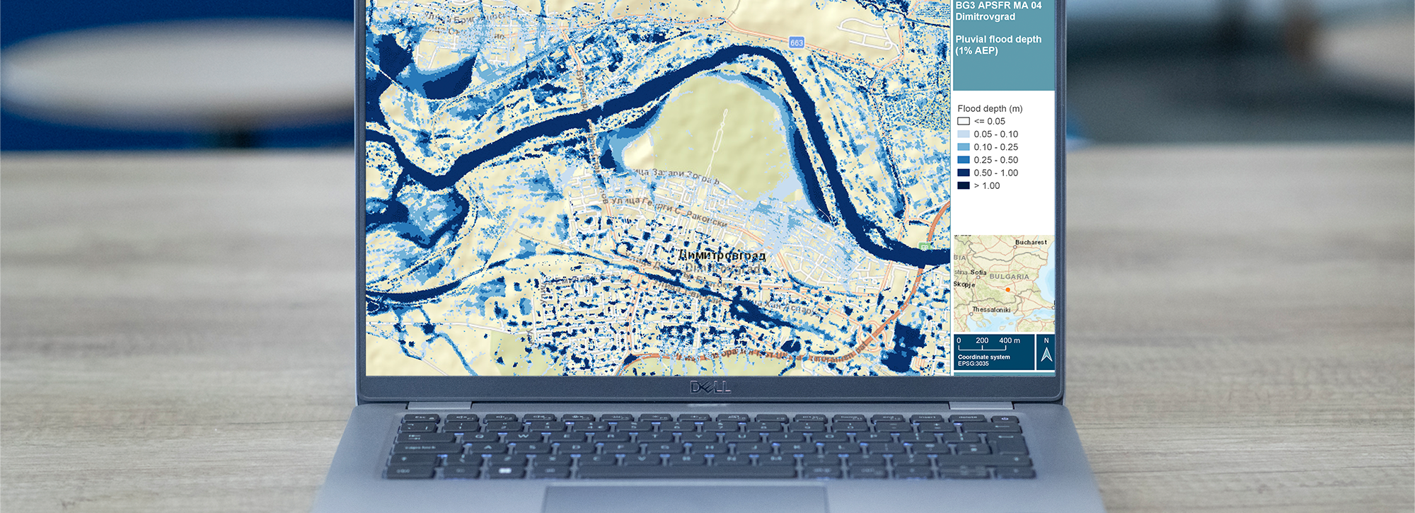
For each flood source we produced maps of flood extent, depth and velocity for three floods - the 5%, 1% and 0.1% annual exceedance probability floods - for present day and two future climate change scenarios.

Our semi-automated approach saved both time and money, and it also increased accuracy. This is because automating the model build gave our experienced modellers more opportunity to fine-tune and enhance the model. This was particularly important where flood defences were missing from survey datasets. Fully-automated post-processing ensured rapid production of consistent and compliant datasets, which were then used to create the maps. 

Flood risk assessments were completed for each probability by taking into account population distribution, building types, economic activity, transport routes, pollutant sources, heritage sites, water bodies and protected areas. The team used AI to process aerial images to plug gaps where there was missing data on building footprints and land cover. In total more than 2,000 individual flood maps - containing 42,000 map sheets -  were produced and disseminated to the River Basin Authorities through an online participatory GIS. 

These maps were used to support public consultation on flood risk management in the priority areas.  

Contact our project lead

Caroline Hazlewood

Director of Water and Climate
Contact Profile

Explore more

  • All
  • Project
  • Expertise
  • News
  • Insight
  • Facility
Emergency services in a water rescue training

Water rescue training

Emergency services in a water rescue training

Water rescue training

Erosion rate measurement

View of a wave generated in our wave flume

Wave flumes

View of fish pass test in volumetric flow flume

Volumetric flow flume

View of fish pass test in volumetric flow flume

Volumetric flow flume

Photo of two people working on the tsunami simulator

Tsunami simulator

Photo of two people working on the tsunami simulator

Tsunami simulator

View from inside our ship simulation center in Australia

Australia Ship Simulation Centre

Wave basins

View inside the UK Ship simulator with screens

UK Ship Simulation Centre

Fast Flow Facility

We are global leaders and independent experts in how to live and work sustainably with water

Social media

  • BlueSky
  • LinkedIn
  • YouTube

Expertise

  • Coastal & marine
  • Energy transition
  • Water & climate
  • Software solutions
  • Equipment & technology

Company

  • About
  • Careers
  • News
  • Insights
  • Sustainability

Legal

  • Privacy & data protection
  • Policies
  • Modern slavery statement
  • Terms & conditions
  • Sitemap
© 2026 HR Wallingford
Contact