
Secondary nav 2022

  • Equipment
  • Software
  • Training

Main navigation 2022

  • About
    • About HR Wallingford
    • Our leadership
    • Our people
    • Our impact
      • Annual report & financial statements
      • Gender pay
      • Social impact
      • Sustainability
    • Our story
    • News
    • Insight articles
    • Policies
  • Projects
  • Expertise
    • Coastal & marine sustainability
      • Coastal hazards & resilience
      • Coastal morphology & sediment dynamics
      • Dredging and sediment management
      • Marine & coastal environment
      • Ports, harbours and shipping
      • Subsea engineering
      • Waterfronts, marinas and resorts
    • Energy transition
      • Fixed offshore wind
      • Floating offshore wind
      • Liquified gas & transition fuels
      • Nuclear
      • Wave, tidal, solar & hydropower
    • Water & climate resilience
      • Dams & reservoirs
      • Freshwater environment
      • Integrated flood management
      • Surface water systems
      • Water management for climate resilient development
      • Water supply & drought resilience
  • Facilities
    • Explore our facilities
    • Ship simulation
      • Australia Ship Simulation Centre
      • UK Ship Simulation Centre
    • Physical modelling
      • Fast Flow Facility
      • Tsunami simulator
      • Volumetric flow flume
      • Wave basins
      • Wave flumes
      • Erosion rate measurement
      • Water rescue training
  • Careers
    • Careers overview
    • Working at HR Wallingford
    • Job opportunities
  • Contact
  1. Home >
  2. Projects >
  3. Sedimentation studies at Tarbela dam, Pakistan

Sedimentation studies at Tarbela dam, Pakistan

Share
View of Tarbela Dam

Tarbela is the largest reservoir in Pakistan and one of the largest in the world. The dam and the reservoir were commissioned in 1974 for the purpose of regulating flow for irrigation and power production. The dam impounds the waters of the Indus River, which carries a heavy sediment load, most of which is trapped in the reservoir. HR Wallingford has been involved in a number of sedimentation studies of this reservoir since the 1990s.

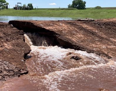
Tarbela reservoir has experienced severe sedimentation, leading to the loss of one third of its total volume due to the accumulated sediment deposits. In addition to losing the volume and thus capacity to regulate the flow for irrigation, the advancing sediment deposits potentially present a threat to the operation of the dam. Rising sediment levels near the dam may block the low-level outlets and impede their continual operation. Sand-sized sediment are starting to pass into the hydropower intakes and this will cause abrasion of turbine blades, leading to increasing cost of maintenance and time when the turbines are out of operation.

HR Wallingford has contributed with designing data collection campaigns, analyses of sediment inflow into the reservoir and advised on possible future sediment management strategies. To quantify the impacts of different future scenarios, we used a selection of 1D, 2D and 3D computer models to simulate sedimentation process in the reservoir at various levels of detail. The typical outputs of the models included prediction of storage loss, annual variation in sediment inflow and outflow, locations, depths and composition of deposited sediment and amount and composition of sediment outflow through different structures.

HR Wallingford has been looking into the sedimentation issues and their solutions in a number of projects listed below.

Sediment management study of Tarbela Reservoir (2011-2013)

The primary objective of the project was to assess the impact of different sediment management strategies, including flushing, at the reservoir and downstream infrastructure at the Indus River. We simulated sedimentation in the reservoir and sediment flushing operations using a dedicated reservoir sedimentation model, RESSASS. Details of sediment and water flow near the dam were modelled separately by a 3D model TELEMAC.  We also performed 2D modelling studies with TELEMAC‑SISYPHE in order to determine the detailed impact of sediment releases on bed levels and sediment concentrations of two downstream impoundments: Ghazi Barotha, located 7 km downstream of the Tarbela dam, and Chashma, about 250 km downstream of the Tarbela dam.

An important part of the project was dedicated to the collection of new field data, particularly regarding sediments. HR Wallingford provided expert advice on the most suitable analysis and collection techniques.

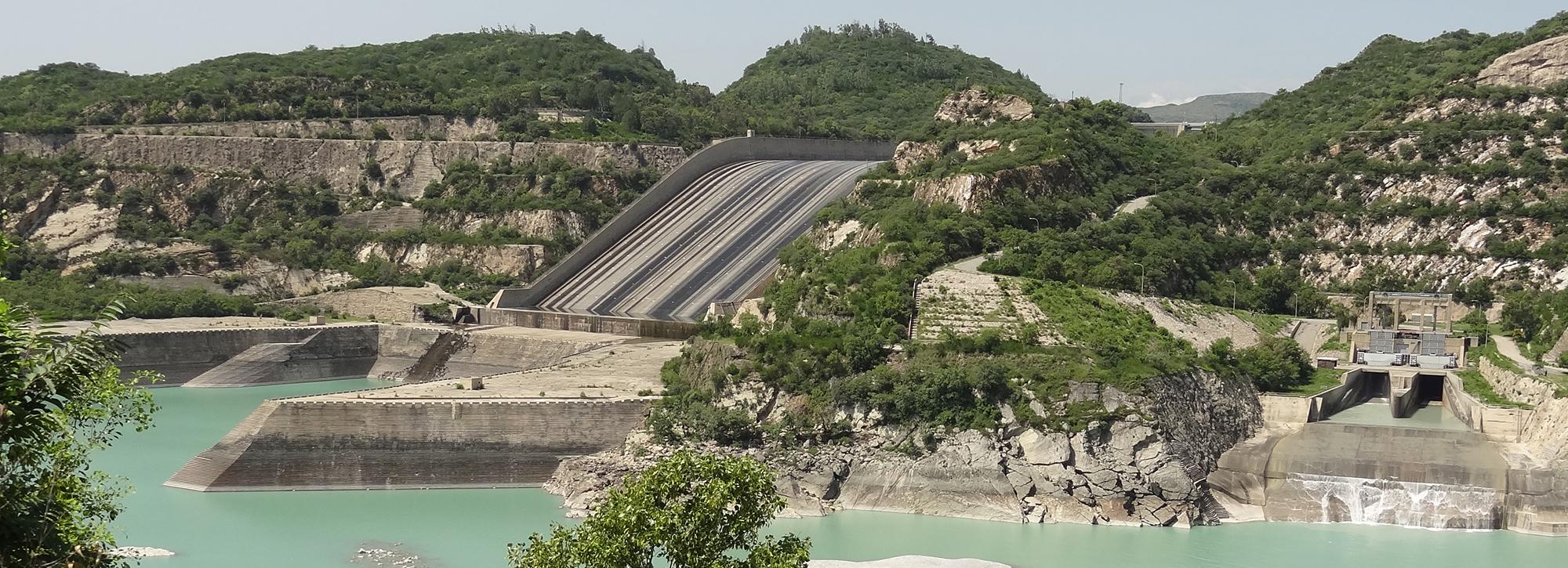
Sedimentation at Tarbela dam

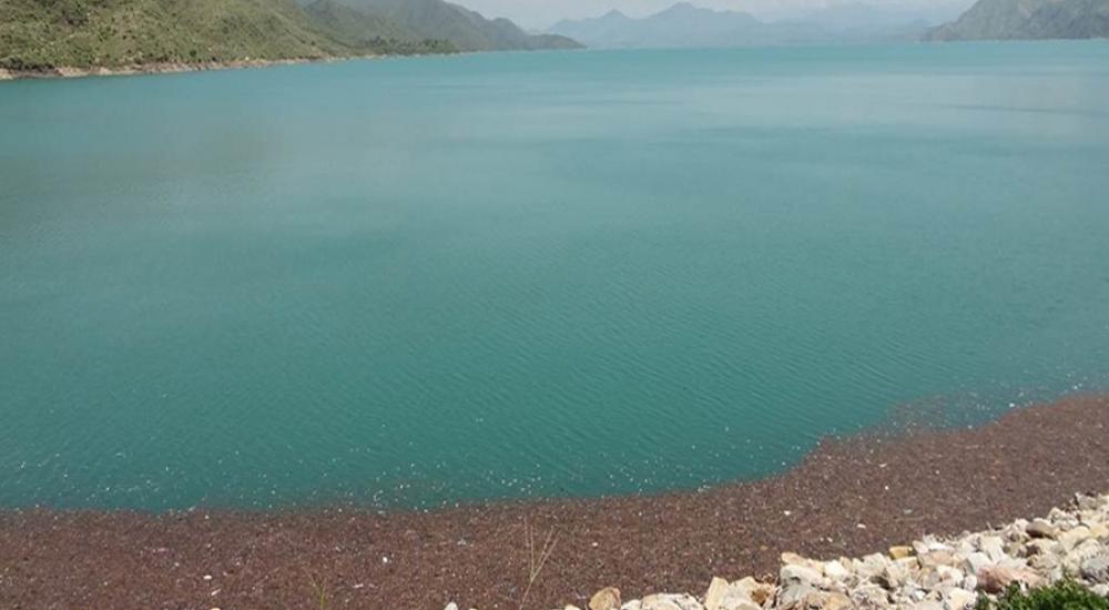
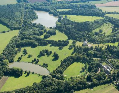
View of Tarbela dam reservoir

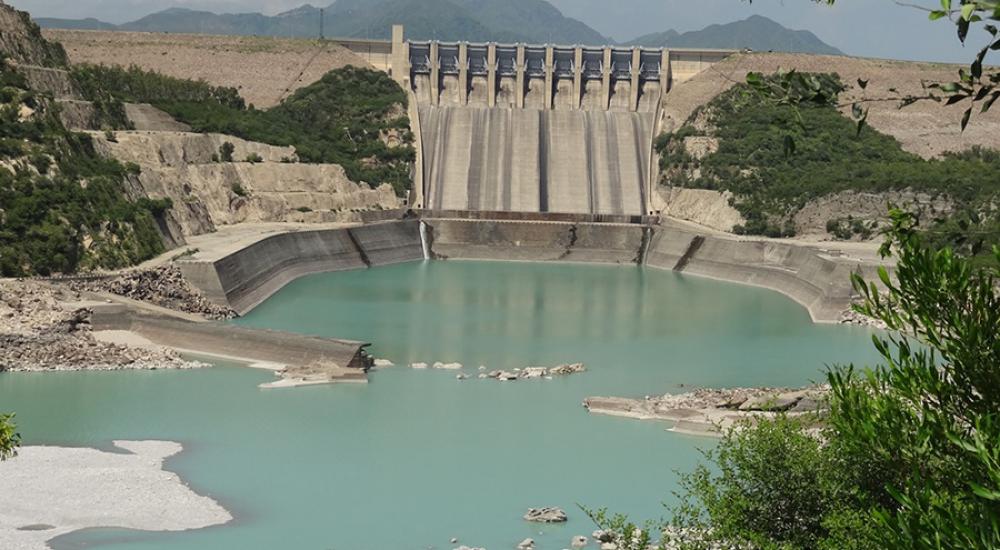
The spillway at Tarbela dam, Pakistan

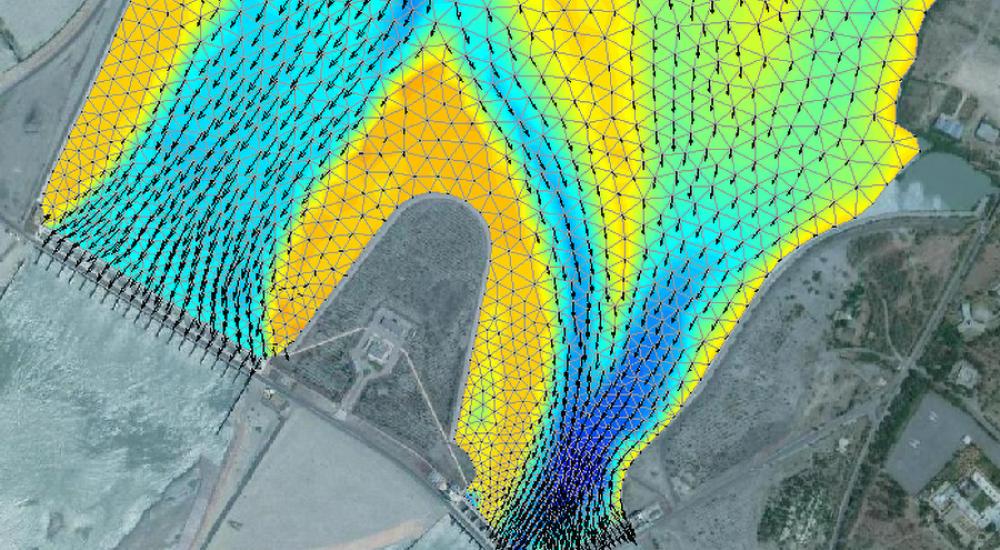
Sedimentation studies using the TELEMAC suite

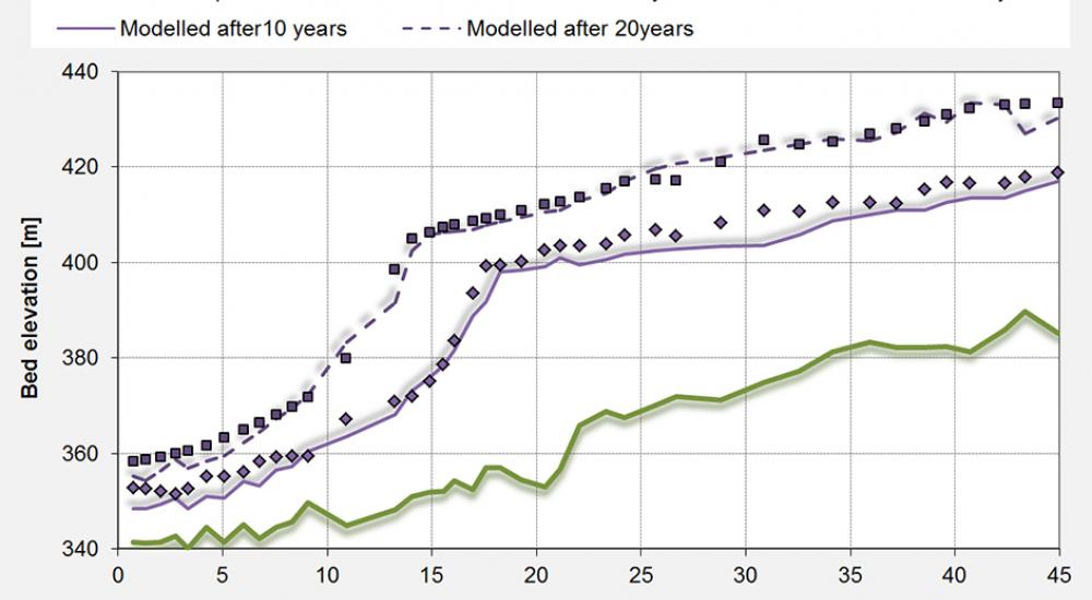
Sedimentation studies using the dedicated reservoir sedimentation numerical model RESSASS

Tarbela 4th extension (2010-2011)

The objective of the 4th extension project is to extend the current installed hydropower capacity determining the optimum design for the scheme. With the numerical model RESSASS we predicted depth-storage curves to assess the reduction of storage capacity and we estimated the sediment sizes and concentrations of the material likely to enter the intake tunnel.

Tarbela Dam sediment management study - Additional studies (2001)

This was an extension to the previous Tarbela Dam Sediment Management Study.  It involved the assessment of the effects of flushing at Tarbela on the downstream river reach, at Ghazi Barotha and along the Indus River up to Attock (about 50 km downstream Tarbela dam). 2D and 1D models were used on that assessment.

A major storage reservoir on the Indus River

Tarbela dam plays a key role in the provision of water for irrigation, power generation and flood control. Sediments have reduced 30% the initial capacity of the reservoir.

Tarbela Dam sediment management study (1998)

In conjunction with TAMS Consultants we determined a strategy for the economical preservation of the Tarbela Dam Project on a sustainable basis. We were involved in the collection and critical review of hydrological and sediment data and the construction and operation of sediment models such as RESSASS. We developed different sediment management strategies that were modelled to make predictions of the sediment delta profile and the storage volumes in the future. The study also included preliminary engineering designs and cost, economic and financial estimates. 

World Bank mission - Tarbela Dam (1995)

We joined a panel of experts in Pakistan to review sedimentation aspects of Tarbela Dam.

Want to know more?

Tarbela Dam in Pakistan. Case study of reservoir sedimentation

Get in touch

Marta Roca Collell

Principal Engineer
Contact Profile

Explore more

  • All
  • Project
  • Expertise
  • News
  • Insight
  • Facility
View of a dam breach experiment

Dam and levee models assessed for predicting internally initiated breaches

View of a dam breach experiment

Dam and levee models assessed for predicting internally initiated breaches

Drainage and Wastewater Management guidance

Rainwater Management Platform: transforming how the UK manages rainwater

SuDS iQ: a digital environment for evaluating and planning good SuDS

Buscot Park lake: a heritage dam reinvented

Automating biodiversity impact assessments with Earth observation

Aerial view of a meandering river

A new Environmental Destination framework

view of people helping during a flood event

Empowering communities to manage local flood risk

Flood early warning system to support tropical cyclone relief

View of brown trout in river

Setting the standards for fish passes

View of brown trout in river

Setting the standards for fish passes

We are global leaders and independent experts in how to live and work sustainably with water

Social media

  • BlueSky
  • LinkedIn
  • YouTube

Expertise

  • Coastal & marine
  • Energy transition
  • Water & climate
  • Software solutions
  • Equipment & technology

Company

  • About
  • Careers
  • News
  • Insights
  • Sustainability

Legal

  • Privacy & data protection
  • Policies
  • Modern slavery statement
  • Terms & conditions
  • Sitemap
© 2026 HR Wallingford
Contact